
A magnitude 7.8 earthquake struck off Sarangani in the southern Philippines on Monday, June 8, 2026, causing deaths, damaging buildings in Mindanao and triggering tsunami warnings across parts of the western Pacific.
The quake hit at 7:37 a.m. local time, with General Santos City and nearby coastal areas among the hardest hit, according to early disaster monitoring and reporting on the southern Philippines earthquake.
The latest Associated Press report, citing officials, put the toll at at least 12 dead and more than 200 injured. Earlier Philippine local reporting cited the Office of Civil Defense as saying 8 reported deaths were still being validated, showing that casualty figures remained fluid as field reports came in from affected areas. The Associated Press reported the updated casualty count.
Table of Contents
ToggleKey Facts
@channelnewsasia A 7.8-magnitude earthquake struck off in the southern Philippines on Monday (Jun 8 ), crumbling buildings and causing panic in the region. Philippines and neighbouring Indonesia have issued tsunami warnings. #philippines #phnews #philippinesnews #earthquake
The Philippine Institute of Volcanology and Seismology placed the quake at sea, about 32 kilometers southwest of Maasim town in Sarangani province, at a depth of 33 kilometers. The U.S. Geological Survey reported a deeper figure of 55 kilometers, a difference that can occur during the early assessment period after a major earthquake.
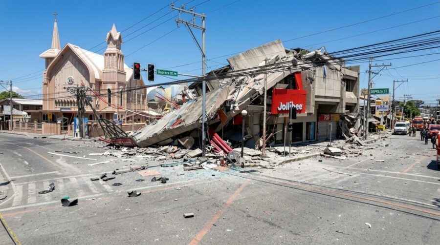
General Santos City, a southern port and tuna export hub with more than 700,000 residents, was among the worst affected areas. Officials reported partial collapses of small buildings, dangerous cracks in a key access bridge and damage to other structures. Authorities were also checking reports that students may have been trapped in a collapsed 2-story school building.
The quake struck on the opening day of public school classes in the Philippines. More than 100 students at morning flag ceremonies suffered bruises or fainted in panic, according to officials. General Santos International Airport was temporarily closed, and 17 domestic flights were canceled.
Latest Verified Update
By late Monday morning, PHIVOLCS had recorded 138 aftershocks, with magnitudes ranging from 1.3 to 6.7. The agency said 47 aftershocks had been located and 9 had been felt by residents in affected areas, according to GMA News live updates.
Tsunami waves were recorded after the quake. Philippine reporting, citing PHIVOLCS, said waves of up to 1.4 meters were detected at several sea-level monitoring stations, with first wave arrival times recorded in Maasim, Kiamba, Kalamansig, Mati City, Zamboanga City and Tandag City.
Government Response
President Ferdinand Marcos Jr. said he had directed relevant government agencies to act immediately. The Office of Civil Defense and the National Disaster Risk Reduction and Management Council were coordinating response and monitoring, while the Department of Social Welfare and Development was told to pre-position relief goods and prepare evacuation centers. The president’s office published the official statement after the quake.
Marcos also ordered class suspensions in affected parts of Mindanao and urged residents in coastal provinces to heed tsunami warnings and move to higher ground. His statement warned residents not to wait before leaving coastal areas at risk.
Why Mindanao Is Vulnerable
Mindanao sits in a highly active seismic zone. PHIVOLCS Director Teresito Bacolcol told local radio that scientists were still analyzing whether the quake was related to the Cotabato Trench, an active offshore fault system associated with major historical earthquakes and tsunamis in the region.
The Philippines regularly experiences destructive earthquakes because it lies along the Pacific Ring of Fire, a belt of active faults and volcanoes around the Pacific Ocean. The country is also among the world’s most disaster-prone nations, with recurring earthquakes, volcanic activity and frequent tropical storms.
What Happens Next
The immediate priorities are search and rescue, casualty validation, inspection of schools, bridges, roads, airports and power infrastructure, and continued monitoring of aftershocks and sea-level changes. The Department of Energy said energy facilities in Sarangani and nearby areas were being assessed through its Task Force on Energy Resiliency, while the Department of Health activated crisis protocols and prepared emergency response teams.
Authorities are expected to update the toll as local disaster offices verify deaths, injuries and structural damage across General Santos City, South Cotabato, Davao Occidental, Sarangani and nearby areas. Until inspections are complete, damaged buildings and coastal zones remain the main public safety concern.
Related Posts:
- Safest Cities in California in 2026: An Honest,…
- The 100 Most Dangerous Cities in America (2026):…
- America’s Murder Capitals - Updated 2026 Rankings of…
- 25 Most Dangerous Cities in US - Updated Statistics for 2026
- Best Places to Retire Abroad in 2026: An Honest…
- Capital Cities in Europe: Top Destinations For You…